Essaouira: the cedar, the skala
One of the beautiful city of Morocco, with its beautiful beach and its blue color, it has one of the most prestigious monuments of the city bleux essaouira the SKALA is at the door of the Navy, to head the Moulay.el up-Hassan and turn left into the Rue de la Kasbah along the ramparts and we follow through. Cross the passage under the arch to discover in the former warehouses of ammunition artisan workshops marquetry. Their works are cedar burl inlaid with satinwood, ebony and sometimes copper wire. Up the ramp leading to the platform of nearly 200 m long, protected from the ocean by a crenellated wall made of boulders sawn. Seen from above, there are still traces of the hole saw and a remnant of the maneuver which served to move these rocks. Beautiful collection of bronze cannons trained on the ocean.
in the year 1184 of the Hegira to connect the port city, it was built by an English renegade. It is OMEE two columns of a triangular pediment classic. The set has a lot of pace. A staircase can sometimes reach the top of the wall of the port Skala and even climb the turrets. Very nice view of the islands and purpuraires on the beach. The guns are polynomials emblazoned Portuguese, Spanish and Flemish. It is in this amazing scene Orson Welles shot scenes for his Othello would win the Palme d'Or at Cannes in 1952.
Mainly devoted to fishing, this is one of the busiest spots in the city, especially the return of the boats. The fish is then sold at auction. A show not to be missed. Access to the port by the customs post at the top of the beach or by the door Madne. The docks are processed in shipyards. You will see the construction of wooden boats as we all do little more built elsewhere. Their shape is reminiscent of the old dhows.
Essaouira is a coastal city situated in the western Morocco. The Berber name of it (tassort) means the wall, a reference to the fortress walls which enclosed the city. The present city was built during the 18th century and in the 19th century during this period Essaouira was the first seaport in Morocco. The city stands on a vast bay with miles of sandy beach on the south and hills on the east. Visitors are usually attracted to its beaches, fresh seafood and medina and the gnaoua music festival.
Essaouira is called the wind city and is good for surfing , with good winds for most days of the year, it is a watersports paradise. But this city is not ideal place for swimming or sunbathing as the water is pretty cold. At the same time the city is protected by the natural bay and water near the coast is almost waveless.
Essaouira is a perfect example of a late 18th century fortified town which presents itself as a city full of culture, several small art galleries can be found all over the town. The Gnaoua Festival of World Music is held in this city in the last week of June, and has been running for over 10 years. But Essaouira's biggest attraction may be its relaxing atmosphere.
The Medina is the walled centre of town and is free of cars and it's also quite clean, it’s a home for many small arts and crafts businesses, the craftsmen are good in making wooden souvenirs such as boxes, chessboards and other kinds of work crafts which you can buy in the city's hundreds of shops, but the souks are great for shopping.
The fortified harbour of the city is a hive of activity with fishing nets laid out on the quayside, boats unloading their catches, fish auctions and stalls serving seafood sizzling on grills.
TransportEssaouira
Most people get to Essaouira by bus since there is no train station. There is a direct daily bus traveling from Casablanca to Essaouira which takes about 6 hours. Buses from Marrakech take around 2.5 hours and several companies travel this route. The bus station at Bab Doukkala in Marrakech is where the buses leave from. Grand Taxis will take you to Essaouira from the Marrakech airport (during the daytime). Alternatively you can get a taxi to the main bus station in Marrakech and then go by bus to Essaouira.
You can walk around Essaouira for the most part, that's the charm of this town. Petit taxis are the best way to get from the bus station to your hotel although taxis can't go into the Medina. You can rent bicycles and motorbikes in the town as well.
Eat and drink
Essaouira is a fishing town and you have to try the local grilled sardines. Any restaurant along the harbour front offers daily fresh fish specials. Some of the best restaurants are in Riads in the medina. The Place Moulay Hassan on the edge of the port is an excellent spot for a drink and some cheap Moroccan food. There are also many reasonable restaurants and cafes on the main streets and squares. The "Alcohol shop", only one in town, can be found outside of Bab Doukkala in a large market street. Mint tea is available all over the town.
The city Dakhla of worlds ..Sahara Dakhla
The city circles Sahara Dakhela
Dakhla, Morocco last town before the border with Mauritania prepares the annual music festival. The event brings together world-renowned superstars as Kadem Saher Cheb Khaled and many others. This is an excellent opportunity to meet and Entertainment
Dakhla was founded in 1502 by Spanish settlers during the expansion of their Empire. The Spanish interest in Western Africa in desert coast of Sahara was the result of fishing activities carried out from the nearby Canary Islands by Spanish fishers and the Barbary pirates menace.
Spaniard fishers were seal fur traders and hunters, fishers and whalers in Sahara coast from Dakhla to Cabo Blanco from 1500 to present, extending by West coast of Africa to whaling humpback whales and whale calves, mostly in Cape Verde, and Guinea gulf in Annobon, São Tomé and Príncipe islands just to 1940. These fishing activities have had a negative impact on wildlife causing the disappearance or endangered of many species, it highlighting marine mammals and birds.[2][3]
They established whaling stations with some cod fishing and trading. In 1881, a dock was anchored off the coast of the Río de Oro Peninsula to support the work of the Canarian fishing fleet.
However, it was not until 1884 that Spain refounded formally the watering place as Villa Cisneros, in the settlement dated in 1502 by papal bull. It was included in the enclaves conceded to the Spanish at east of the Azores islands. In 1884, the settlement was promoted by the Spanish Society of Africanists and funded by the government of Canovas del Castillo. The military and Spanish Arabist Emilio Bonelli recognized the coast between Cape Bojador and Cabo Blanco, founding three settlements in the Saharan coast: one in Villa Cisneros in honor of cardinal Francisco Jiménez de Cisneros, another in Cabo Blanco for seal hunting, which gave the name of Medina Gatell, and another in Angra de Cintra with the name of Puerto Badia, in honor of the Arabist and adventurer Domingo Badia. Bonelli got the native inhabitants of the peninsula de Río de Oro signed an agreement which placing them under the protection of Spain. Thanks to the presence of the three seatlements in December that year The Spanish government put in communication of the Collonial Powers assembled at the Berlin conference, which was adjudged possession of the territory lying between Cape Bojador and Blanco.
During the colonial period, the Spanish authorities made Dakhla the capital of the province of Río de Oro, one of the two regions of what was known as Spanish Sahara. They built a military fortress and a modern Catholic church, both of which remain points of interest for visitors to the city. A prison camp also existed here during the Spanish Civil War, at which writers such as Pedro García Cabrera were imprisoned.
During the 1960s, the Francoist dictatorship also built here one of the three paved airports in Western Sahara at Dakhla Airport. Between 1975 and 1979, Dakhla was the province capital of the Mauritanian province of Tiris al-Gharbiyya, as Mauritania annexed portion of Western Sahara. Dakhla Airport is used as public airport and by the Royal Air Maroc. The 3 km. long runway can receive a Boeing 737 or smaller planes. The passenger terminal covers 670 m² and is capable to handle up to 55,000 passenger/year.
For lovers of snow sports know that the city is located at the edge of the Atlantic Ocean and has several beaches where beach lovers can enjoy swimming and other water sports, including fishing line, deep sea fishing, surfing, skydiving sea environment also lends itself well to scuba diving, water skiing or jet ski.
Chefchaouen: A city in northern Morocco
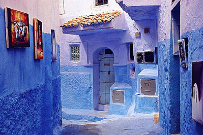
It is a city in northwest Morocco nestled at the foot of jebels Kelaa and Meggou, which form the Jebel Ech Chefchaouen in the Rif Mountains, the city has 42,000 inhabitants, capital of the province of the same name. It is located 600 m above sea level. The name of the city means in Amazigh Rif "horns" Achawen because mountain peaks overlooking the city and entourennt. It was founded in the year 876 of the Hegira, or in 1471 AD by Moulay Ali Ben Moussa Ben Rached El Alami. The province of the same name, with 440,000 inhabitants, the population density is 101 inh. / Km ² and the area of 4350 km ².
Dakhla was founded in 1502 by Spanish settlers during the expansion of their Empire. The Spanish interest in Western Africa in desert coast of Sahara was the result of fishing activities carried out from the nearby Canary Islands by Spanish fishers and the Barbary pirates menace.
Spaniard fishers were seal fur traders and hunters, fishers and whalers in Sahara coast from Dakhla to Cabo Blanco from 1500 to present, extending by West coast of Africa to whaling humpback whales and whale calves, mostly in Cape Verde, and Guinea gulf in Annobon, São Tomé and Príncipe islands just to 1940. These fishing activities have had a negative impact on wildlife causing the disappearance or endangered of many species, it highlighting marine mammals and birds.
They established whaling stations with some cod fishing and trading. In 1881, a dock was anchored off the coast of the Río de Oro Peninsula to support the work of the Canarian fishing fleet.
However, it was not until 1884 that Spain refounded formally the watering place as Villa Cisneros, in the settlement dated in 1502 by papal bull. It was included in the enclaves conceded to the Spanish at east of the Azores islands. In 1884, the settlement was promoted by the Spanish Society of Africanists and funded by the government of Canovas del Castillo. The military and Spanish Arabist Emilio Bonelli recognized the coast between Cape Bojador and Cabo Blanco, founding three settlements in the Saharan coast: one in Villa Cisneros in honor of cardinal Francisco Jiménez de Cisneros, another in Cabo Blanco for seal hunting, which gave the name of Medina Gatell, and another in Angra de Cintra with the name of Puerto Badia, in honor of the Arabist and adventurer Domingo Badia. Bonelli got the native inhabitants of the peninsula de Río de Oro signed an agreement which placing them under the protection of Spain. Thanks to the presence of the three seatlements in December that year The Spanish government put in communication of the Collonial Powers assembled at the Berlin conference, which was adjudged possession of the territory lying between Cape Bojador and Blanco.
During the colonial period, the Spanish authorities made Dakhla the capital of the province of Río de Oro, one of the two regions of what was known as Spanish Sahara. They built a military fortress and a modern Catholic church, both of which remain points of interest for visitors to the city. A prison camp also existed here during the Spanish Civil War, at which writers such as Pedro García Cabrera were imprisoned.
During the 1960s, the Francoist dictatorship also built here one of the three paved airports in Western Sahara at Dakhla Airport. Between 1975 and 1979, Dakhla was the province capital of the Mauritanian province of Tiris al-Gharbiyya, as Mauritania annexed portion of Western Sahara. Dakhla Airport is used as public airport and by the Royal Air Maroc. The 3 km. long runway can receive a Boeing 737 or smaller planes. The passenger terminal covers 670 m² and is capable to handle up to 55,000 passenger/year.
Beni Mellal booming agricultural town
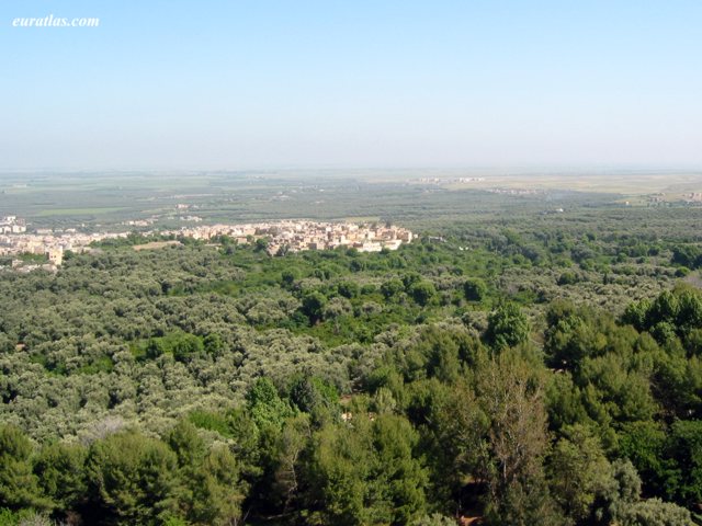
Morocco holidays Booming agricultural town, Beni Mellal is surrounded by a luxuriant oasis which runs on one of the hills of Dir, between the Middle Atlas and the vast plain of Tadla cereal. These are the major irrigation works thereof, made possible by the proximity of such immense bin el Ouidane, who favored the development of this huge orchard with beautiful orange succeed on the heights of beautiful olive groves flourish where fig, pomegranate and apricot.
The kasbah, built around 1688 under the reign of Moulay Ismail, has been amended several times. The center of the city, near the place where the market is held (Tuesday), you will be able to acquire hanbels, large blankets garish hues.
Beni-Mellal was known under the name Day. Next to Day, another small town was born: Soumaa. The Soumaa zawiya is founded by Sidi Ahmed Ibn Kassim Soumai in the sixteenth century. This zawiya had a big role in this region. The merger of these two towns gave Beni-Mellal current.
At the entrance of the city, a good road (follow the sign "tour") past the modern building of the province can do around the oasis (625 m) of Beni Mellal, which extends foot of Jebel Tassemit (2248 m). It passes near the source Vaucluse Ain Asserdoun (3.5 Km) around which were arranged charming gardens. From there, a small road goes to the Kasba Ras and Ain (1km), but nicely located in ruins; sweeping views of the city and its surroundings.
About Beni Mellal.
1 - Taghzirt (22 Km north-east by the CT1674) A 10 km from Beni Mellal is the village of Ait Said, established at the mouth of the ravine Foum el Anseur at the bottom of which flows a stream fed by six sources. Springing from cliffs of dizzying heights, they irrigate plantations hackberry, walnut, olive, fig, apricot, orange, banana, etc.. At the top of the cliff several artificial caves were prehistoric shelters. Very difficult to reach these caves have excited the popular imagination: the legend they contain treasures guarded by petrified characters.
Fichtala (about 14 km) is the seat of Zawiya. It was there in 1545 Marmol up Efza, the capital of Tadla. It is probably the Tefza mentioned by the Andalusian historian Leo Africanus, near which the saadien Ahmed el Arej defeated the Wattasids in 1536. We then joined Taghzirt an old bourgae with a kasbah.
2 - Dam and Lake bin el Ouidane (58 Km south by P24, the 1802 and S508A). Beni Mellal leaving the South, we quickly reached the first slopes of the Middle Atlas. A Oulad Moussa (11km), turn left onto 1802. From Ouaouizarth the road (S508A) along the Lake Bin el Ouidane formed by the impoundment of the Wadi el Abid. The rugged mountains of the High Atlas link first identify their walls red and brown the vast expanse of blue water. it is possible to swim from the tourist complex built on the north shore of the lake.
An area equal to that of Lake Annecy, the lake is closed to the west by the imposing dam of the same name. This high curved wall 130 m high and 290 m long, over which passes the road from Azilal Afourer, was built between 1948 and 1955 in a gorge aspect Jura. it feeds a power plant, and allows irrigation of the plain of Tadla. This is one of the most important works of Morocco. A few kilometers downstream is a second high dam, says Ait Ouarda.
Asilah city..Morocco holidaysin
Asilah city is famous for its long sandy beaches. Whether it is one that is close to the city center, or of Rmilat, 4 km from the city.
Walks on the ledge at the edge of the sea remains very popular and restaurants offering quality fish abound. Today, sports activities and develop a new marina will soon be ready to receive yachts worldwide. It is already possible to fishing. Similarly, the vast expanse of beach is perfect for enjoying long walks, horse or camel.
Asilah Morocco, this small trading town, over 3,600 years old, is situated on the northwest tip of Morocco. Until 1978 the town was deteriorating behind the ancient defensive walls that still enclose it. That situation was soon changed by the ideas of one man, Mohammed Benaissa, by his belief in culture as an invaluable resource and his dreams for his hometown. Through the efforts of Benaissa and his colleague, another local resident, Mohammed Melehi.
The annual cultural festival of Asilah was created to fund the rehabilitation of the town, an effort continuing today. The rehabilitation project is heavily intertwined with the creation of the festival and the story of the two men. In 1989 the town won an Aga Khan Award for its rehabilitation efforts. Asilah has been granted a whole new life but raises issues related to the continuing development of the town and its inhabitants.
Asilah is located 42 km southeast of the town of Tangier on the Atlantic coast. The town is completely surrounded by Portuguese defensive walls that were erected in the 15th century. (Images 1 & 2) There are extensive beaches and a natural harbor on the northwest side of the town. Farmlands surround the town and there are no factories in the immediate area., to the north of Asilah beach resorts and to the southeast lie squatter settlements called mixik. This northern Atlantic coastal area falls into the Mediterranean climate zone bringing mild wet winters and dry warm summers. The presence of the Atlantic creates more rainfall than in the other Mediterranean areas.
Asilah's history stretches back to around 1500 BC, since then it has changed hands several times. The significance and morphology of the town is linked to its natural harbor. The Phoenicians called it Silis or Zilis and used the town mainly as a trading post. Being at a favorable location at the crossroads between the East and West, it was later occupied by the Carthaginians, Byzantines, and the Romans. In the 9th century it was occupied by the Arabs and the Normans.
In 1471, Asilah was occupied by the Portuguese who built the town's fortifications. It was voluntarily returned to Morocco in 1550, but was absorbed by the Spanish as they took control of Portugal in the late 16th century. In 1692 the town was recaptured by the Moroccans under the leadership of Moulay Ismail. In the 19th and 20th centuries Asilah was a base for piracy. In 1911 Spain took the northern portion of Morocco as their protectorate which included Asilah. The country finally gained its independence in 1956.
Souk {EX El Had} of morocco
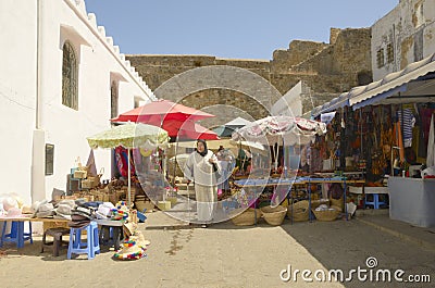
Souk El Had and Agadir is not only the largest urban souk in Morocco, but also the largest in Africa. With 3,000 stores, including 1,500 stores and 1,500 commercial tile, Souk Al Had differs from other souks that it is a souk urban open 6/7, closed only on Mondays for cleaning.
It is also a very popular souk both by locals and by domestic visitors and tourists. It is the attraction most important commercial destination in Agadir and across the region. Therefore, it has nothing to do with the other rural weekly souks are held in Moroccan villages. Another feature of Souk Al Had and it generates business transactions valued at more than a billion cents per week, or about 50 billion pennies a year, though some observers are lower than this figure that generates souk. Here it is truly unbeatable and deserves its ranking Souk Urban No. 1 in Africa.
Souk Al Had is built on 11 hectares, with two hectares in extension now. It has been strengthened in recent years with the construction of the walls surrounding it and have well developed. The tents were removed, and the development work of 2009 completely highlighted the souk: metal frames, flooring and sanitation, feeder drinking water (in progress) and opening of the extension adjacent to with new stores planned for summer 2011. The extension aims to release passages ensure a smoother, more space for movement with the primary and secondary axes that are more liberated. This will also provide an opportunity for more effective interventions possible firefighters and others.
Another feature of Souk Al Had and generates 10,000 jobs across different business: fruits and vegetables, crafts, meat, clothing, local produce, dried fruit, furniture, electrical household etc. ... So everyone can find what they need in a wide variety. It is almost a place where you can find a little of everything. This is what drives people to go. It is estimated that at least 1,500 visitors per day, a significant increase during the weekend and especially three days before religious festivals. There souk displays its full force and legends are jostling around. Souk al Had is really essential.
Managed by the Municipal Council Agadir, souk also enjoys a good intervention of local authorities with the presence on site of an office for a Khalifa who is responsible for security in the souk and application of the regulations in force, the fight against the various crimes and misdemeanors in full collaboration with representatives of the municipal council of Agadir. A police station also enhances participation in the stewardship of the souk. Besides improving safety is seen by the local authorities and will allow coverage of the souk 24/24, day and night. This is also the dimension that demonstrates that there is a very specific case about a very specific urban souk in all its components.
Remains to note that the greatest attraction of the souk is the display of fruit and vegetables produced in the region. There are almost all kinds of fruits and vegetables, filed in bulk, which gives a picture of the diversity and quantity (both in fact and quality) of the citrus production which ensures the Souss alone 60% of national exports.
walili city in history ancient face of morocco
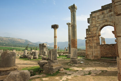
Walili (Volubilus) is an ancient Roman town situated on the banks of Oued Khoumane river on the outskirts of Meknes (Morocco), A History of the monument north side of Fez is Morocco's leadership Mouley Idriss Ters beautiful city.
the name of the city Walili (Volubilis) the name of the smells of buckwheat, the city lived trade olive oil, it was built by the Roman quality of preservation of the mosaics and the exceptional preservation of the site led to the UNESCO World Heritage classify humanity.
Walili: Alili: oleander in Amazigh. Walili would name it to Amazigh laurel or would it be the deformation of Latin Volubilis? Volubilis is an ancient city Mauritanian whose existence is attested from the fourth century BC. It is situated on the banks of the Khoumane river on the outskirts of Meknes (Morocco), near the holy city of Moulay Idriss where I rest Idris. It was built on a spur overlooking the Khoman and surrounded by a wall Hellenistic east and north.
This wall reveals the presence Punic its construction techniques and everyday objects. Monumental inscriptions in Punic writing the second century BC Punic confirm the impact and also attest to function Suffet Volubulis from the third century BC. The Neo Punic inscriptions testify to the persistence of the Punic language until the time of Juba II and Ptolemy. Temple B outside of the wall and Mauritanian called Temple of Saturn continued to be used since the tragic death of Ptolemy to third centuries AD. The sanctuary whose ritual reminiscent of a Tophet was probably dedicated to a deity Amazigh whose name is not known and should not be confused with Saturn the rest of the African [[Numidia]]]].
Subscribe to:
Posts (Atom)